Projects
November 2008
Thai/Burma Boarder
I tend to prefer the places that Lonely Planet only generates a paragraph about, for these are the places where culture dwells and tourists do not. Today I learned that the size of the world is not fixed; original experience is more abundant than arm-chair adventurists have led me to believe. Three months ago when I committed to working for BMWEC and the Hussmann Foundation I pictured myself working in refugee camps with Karen, Burmese refugees, slipping on identities like over-coats. Instead, Nowhere is turning out to be a land of heroes and compassion making it very hard to act in any other way than how I feel.
So, as for the apprehensiveness? It has been extinguished by the two-hundred and fifty teachers I saw today, all contributing to something bigger (6,200 Burmese refugee children, to be exact). Subsequent posts will surely see times of un-governed happiness just as they will unparalleled empathy. My thoughts will be unedited and I welcome your replies.


Yesterday I wrote off the walls of limestone encrusted valleys as an endless uphill battle. Today is different, today has started with a new feeling--the last day on the bike of a human powered journey covering over 2,000 kilometers. Though I'm not feeling fresh, I saddle up with a smile. Today I will ride to the ceiling of Vietnam; Tram Ton Pass.
There are bright colored hill tribe women trading goods at the market, chiefly, H'Mong and Black Thai. The ebbs and flows of the market are a 3D screen-saver; uneventful and constantly entertaining.
One last sip of coffee.
I start pedaling.
***
The remote border crossing in the mountains of Lao/Vietnam border territory, tape-worm-roads, and agricultural shelves in the Vietnamese highlands near China can most aptly be described as having more variety than I normally desire; a stiff Caucasian of "ins, outs, and what-have-yous."
The last three weeks was a head-first dive into a muddy river; I bumped into some interesting things. On the eve of my birthday I was in the remote town of Hat Lok. At 11:37am a moped sped by, nearly nicking my left shoulder. Fifty yards down the road the driver hit an elderly man, approximately fifty more and he drove into a group of young school children on their lunch break. The children blew over like tall grass when the wind blows. The universe skipped a beat as the moped went airborne, spinning and twisting, while spirals of injustice were changing the future for people stuck on the ground.
I reverted to my EMT training. After assessing the scene and the victims I was forced to leave the scene of one dead moped driver who's breath smelt of booze, an elderly man with badly bruised ribs, and a paralyzed young boy. I rode past the dead drunk driver and away from the young paralyzed boy, in a culture that does not cater to the handicapped.
***
Now, I've hung out in the peloton with roadies (road bike racers) and talked about how many ounces my wheels weigh; I've gone scientific on race nutrition and training strategies with tri-geeks (triathletes); when 500 hipsters from Critical Mass took over the Alaskan Viaduct on two wheels and one gear I helped block on-coming traffic (www.seattlecriticalmass.org); and last year my dad rode the entire West Coast of the United States with his brother Chris (way to go Pa!). The undeniable characteristic in all these groups is the desire to approach life at one's own speed.
From the rear-pocket handkerchief hanging hipsters on single speeds at Critical Mass to my friends stuck inside on their trainers out of fear of damaged bearings, there is one agreed upon common ground. In every possible figurative and literal interpretation--riding a bike epitomizes freedom.
On December 2nd, the day before my birthday, I was reminded how fortunate we are to share this freedom, to move and utilize our senses; relish in your aliveness.
***
It's cold now. I look up and it's the same flat white. I've been climbing the same ridge line for 25km and haven't broke through the fog. The concept of wind resistance has been introduced. Every time I round a hair-pin the wind stands me up with enough force to float me back to the rice paddies a thousand meters below. My water is gone, my fingers are gripping the bars disconnectedly, and I'm reaching deep fatigue.
Fatigued, not tired. Note the difference.
This has got to be the last corner.
I round the bend, visibility improves with the worsening head wind, a half-mile across the valley and looming two thousand meters above I can make out a shiny piece of silver. The silver line hanging precariously on the opposite ridge is sloping up at a 5-6% grade. "Maybe it's a new pipeline?" I think out loud.
I know God-Damn well what it is; a new guard rail.
Two hours later the shiny rail is on my right side and I reach the top of Tram Ton Pass. My reward: a billboard and a large group of photohappy tourists snapping pictures of each other on a big pile of dirt.
A brief visual description of what lies beyond the pile of dirt:
http://www.youtube.com/watch?v=DeutFlSpYVM
***
After three days of recovery in Sapa the fog lifted. Sapa is full of tourists but it still serves as a trading spot for three different types of hill tribe people living nearby. My immune system decided to quite working after I made it over the pass (deeply fatigued... Not tired) but by day three I was ready for the final ascent of the tour; Mt. Fanzipan.
Peddling up the backside of Tram Ton Pass I got my first look at the objective. Carst limestone ridges leading to committing summits surrounding the highest mountain in Indochina. Unlike it's neighbors, Mt. Fanzipan is a big uneventful lump covered in fog six out of seven days.
Five minutes past, I made a judgement call, coasted 30km down the road I struggled up three days prior, summited Tram Ton Pass a second time with clear skies as a backdrop, and coasted past Sapa down to the Red River 5km from China.
***
I'm at the base of a route called Elephant Man, it's overhung and my upper body is atrophied; for the past month my legs have been stealing all the nutrients. The crag is called Butterfly Vally and it lives up to it's name with a diverse local population of our delicate two whinged friends. I wasn't planning on guiding on the island, nor was I keen to shell out $15USD for gear to climb. The owner of Slo Pony Adventures and I worked out a deal which basically allowed me to climb five days a week and work one or two.
I lead kayak trips and belayed first timers in exchange for climbing gear and good company. Most of the clients were better suited for the party barge...
Cat Ba was my shelter from the storm.
For pictures of climbing Cat Ba Island peruse the picture and video tab on left of this URL:
http://www.slopony.com/
***
I am passing on the Iguana to an expat inspired to tour.
Happy Holidays.
Get busy livin'
Andrew

When a person rolls into town on an iron donkey people ask questions. We must look like a couple of lost gypsies.
Buggy (unaffectionate bike name) has a massive yellow bag mounted on a single axle trailer with a broken rear fender that rubs on the wheel. Kitchen equiptment and other essential crap hang off in all directions. We must look lost, but we seem to be making a lot of friends this way.
Rodrigo is a guide here in Pucon. He popped out as soon as our wheels stopped rolling and offered a place to pitch the tent. Yesterday he took us up a dirt road towards volcano Villarica. We crossed three ridges and swooped up through several different glacial fed rivers before ditching the bikes and hiking up to a waterfall. Rigo is full of life and knowledge. He´s a guide on the volcano and super fit local adventure buddy.
We are tentatively planning to race the Ironman Pucon 70.3 here on the 16th. The town is nestled between a massive lake and subtropic mountains. We´ll be running wild and free in the mountains until race morning.
Becky is still working on a name for her steed, but I think she´s settled for Julio.
Post race we will tour all the way south.


Took the bus from Bariloche and bopped up to the alpine climbing up, Refugio Frey. The weather was crap. Hissing rain as I arrived, a ways ahead of Becky. A bunch of longed hairs were crowded in the refugio, most spoke english and claimed to be native to Colorado. Typical. We opted to test the tent and awoke to several inches of snow and blue sky. Weather is changing. Trail qaulity was a highway. Not technical. Follows a river until the final hour which is a steep up to attain the saddle. Refugio sits on a lake in the saddle. Surrounded by towers to climb. Total run/approach = 4hrs


We have come from Pucon, subtropic rides and runs through lush understory. Popped out the other side of the Andes to Argentina where everything is a bit more serious. In the morning we will get our first taste of route 40. There are no towns for the next 3 days. Resting today and gunning for Butch Cassidy´s old stomping grounds. The above sequence shows the weather and terrain change in the past week or so.


Pictures:
1. Scene through the Andes.
2. Fish Shape Shack in Manihuels. We were invited to stay at the guy in the middles house. The guy on the right is his fishing partner who also molds fish for wall mounts.
3. Where the fish was caught
4. We brought this thing in as a collective. Storm on the hills. Rain. Wine. Really good din din.
Manihuels is on the Carreta Austral in Chile. 500 people or less in the town. Really nice people welcome you in. So pure.


 *Photos: Eddie Gianelloni
-->

I’m on a search for the perfect ride; a simplified and stripped down perspective--every day. From the saddle of a bike, outside the breakers at dawn, or chasing alpenglow on a new trail; simple pleasures. "Simplify, simplify." A tape worm road through a range I've never ridden, Hank Williams shouting through headphones, off camber turns, goose bump arms; child-like smile. Running a trail, steep enough to require thought, technical enough to stay present; freedom, solitude, and independence--that is why we go. Perspective, inspiration, and a spanking--that is what we get. I play outside because it’s fun, the faster I go the more fun I have.
 Day 1:
Mid: 90 mile ride w/ 9,000ft vert on Mt. Palomar; world class riding. http://www.mapmyride.com/us/valley-center-ca/mt-palomar-long-loop-route-946045
Petzl...best headlamps on the market
Smart Cells...insoles for long days and recovery
Woodinville Bicycle...I don't care who you are or where you live, this shop is better.
Orca/Orbea...Keeping aero sexy
***
Mom, Dad, Allison, Mathew, Alycia; I am nothing without you.
***
Pictures from the trip that I can't seem to get perfect; very organic.


Until next time,
This can’t be happening. Droplets of sweat slide brow to brim, then ramp off my nose splattering on concrete hot enough to boil. With a shirt like a damp wool blanket in an overheated house, uncomfortable and oppressive, I start unpacking my gear. It’s busy and loud just outside the rural airport, no goats on the runway but not far from it. The exit of baggage claim is a cocktail of energy; cowboys lean over a metal guardrail to welcome arriving family, women laugh and talk loudly in small circles, and kids are running around everywhere. I’m the sweaty dude dragging a bucket load of gear through the open air terminal.
Thai/Burma Boarder
First Dispatch
Today was a very good day. Last night? Apprehensive. But today, ah, today was the introduction to a world I’ve never known.
We’ve all been to Nowhere. It might have been in the middle of Seattle or Saskatchewan. It might have been at a Zen monastery, a no-man’s-land border outpost, or a bungalow in a nameless beach town. You may have found Nowhere on a sultry summer night in Paris when you’d spent your last euro and had no place to sleep; or on a midnight jeep safari in the Botswana bush after you’d blown your last spare tire, with your campsite a distant pinprick of light; or in the comforting cocoon of an all-night train compartment, sharing soul-secrets with a total stranger. Nowhere is a setting, a situation and a state of mind. It’s not on any map, but you know it when you’re there.
This time it has taken, as it usually does, a tremendous amount of energy and an open mind to get to Nowhere. This time, Nowhere is Mae Sot, Thailand.

I tend to prefer the places that Lonely Planet only generates a paragraph about, for these are the places where culture dwells and tourists do not. Today I learned that the size of the world is not fixed; original experience is more abundant than arm-chair adventurists have led me to believe. Three months ago when I committed to working for BMWEC and the Hussmann Foundation I pictured myself working in refugee camps with Karen, Burmese refugees, slipping on identities like over-coats. Instead, Nowhere is turning out to be a land of heroes and compassion making it very hard to act in any other way than how I feel.

So, as for the apprehensiveness? It has been extinguished by the two-hundred and fifty teachers I saw today, all contributing to something bigger (6,200 Burmese refugee children, to be exact). Subsequent posts will surely see times of un-governed happiness just as they will unparalleled empathy. My thoughts will be unedited and I welcome your replies.
---------------------------------------------------------------------------------------------------------
Human Powered Across Southeast Asia
December 2008

The sun is up. The low hanging ceiling of fog is receding, revealing ridge lines puff painted in green fauna. The old white sheet lifts, the scene is set.
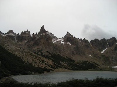
Yesterday I wrote off the walls of limestone encrusted valleys as an endless uphill battle. Today is different, today has started with a new feeling--the last day on the bike of a human powered journey covering over 2,000 kilometers. Though I'm not feeling fresh, I saddle up with a smile. Today I will ride to the ceiling of Vietnam; Tram Ton Pass.
There are bright colored hill tribe women trading goods at the market, chiefly, H'Mong and Black Thai. The ebbs and flows of the market are a 3D screen-saver; uneventful and constantly entertaining.
One last sip of coffee.
I start pedaling.
***
The remote border crossing in the mountains of Lao/Vietnam border territory, tape-worm-roads, and agricultural shelves in the Vietnamese highlands near China can most aptly be described as having more variety than I normally desire; a stiff Caucasian of "ins, outs, and what-have-yous."
The last three weeks was a head-first dive into a muddy river; I bumped into some interesting things. On the eve of my birthday I was in the remote town of Hat Lok. At 11:37am a moped sped by, nearly nicking my left shoulder. Fifty yards down the road the driver hit an elderly man, approximately fifty more and he drove into a group of young school children on their lunch break. The children blew over like tall grass when the wind blows. The universe skipped a beat as the moped went airborne, spinning and twisting, while spirals of injustice were changing the future for people stuck on the ground.
I reverted to my EMT training. After assessing the scene and the victims I was forced to leave the scene of one dead moped driver who's breath smelt of booze, an elderly man with badly bruised ribs, and a paralyzed young boy. I rode past the dead drunk driver and away from the young paralyzed boy, in a culture that does not cater to the handicapped.
***
Now, I've hung out in the peloton with roadies (road bike racers) and talked about how many ounces my wheels weigh; I've gone scientific on race nutrition and training strategies with tri-geeks (triathletes); when 500 hipsters from Critical Mass took over the Alaskan Viaduct on two wheels and one gear I helped block on-coming traffic (www.seattlecriticalmass.org); and last year my dad rode the entire West Coast of the United States with his brother Chris (way to go Pa!). The undeniable characteristic in all these groups is the desire to approach life at one's own speed.
From the rear-pocket handkerchief hanging hipsters on single speeds at Critical Mass to my friends stuck inside on their trainers out of fear of damaged bearings, there is one agreed upon common ground. In every possible figurative and literal interpretation--riding a bike epitomizes freedom.
On December 2nd, the day before my birthday, I was reminded how fortunate we are to share this freedom, to move and utilize our senses; relish in your aliveness.
***
It's cold now. I look up and it's the same flat white. I've been climbing the same ridge line for 25km and haven't broke through the fog. The concept of wind resistance has been introduced. Every time I round a hair-pin the wind stands me up with enough force to float me back to the rice paddies a thousand meters below. My water is gone, my fingers are gripping the bars disconnectedly, and I'm reaching deep fatigue.
Fatigued, not tired. Note the difference.
This has got to be the last corner.
I round the bend, visibility improves with the worsening head wind, a half-mile across the valley and looming two thousand meters above I can make out a shiny piece of silver. The silver line hanging precariously on the opposite ridge is sloping up at a 5-6% grade. "Maybe it's a new pipeline?" I think out loud.
I know God-Damn well what it is; a new guard rail.
Two hours later the shiny rail is on my right side and I reach the top of Tram Ton Pass. My reward: a billboard and a large group of photohappy tourists snapping pictures of each other on a big pile of dirt.
A brief visual description of what lies beyond the pile of dirt:
http://www.youtube.com/watch?v=DeutFlSpYVM
***
After three days of recovery in Sapa the fog lifted. Sapa is full of tourists but it still serves as a trading spot for three different types of hill tribe people living nearby. My immune system decided to quite working after I made it over the pass (deeply fatigued... Not tired) but by day three I was ready for the final ascent of the tour; Mt. Fanzipan.
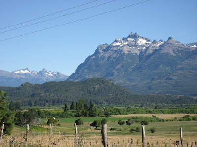
Peddling up the backside of Tram Ton Pass I got my first look at the objective. Carst limestone ridges leading to committing summits surrounding the highest mountain in Indochina. Unlike it's neighbors, Mt. Fanzipan is a big uneventful lump covered in fog six out of seven days.
Five minutes past, I made a judgement call, coasted 30km down the road I struggled up three days prior, summited Tram Ton Pass a second time with clear skies as a backdrop, and coasted past Sapa down to the Red River 5km from China.
***
I'm at the base of a route called Elephant Man, it's overhung and my upper body is atrophied; for the past month my legs have been stealing all the nutrients. The crag is called Butterfly Vally and it lives up to it's name with a diverse local population of our delicate two whinged friends. I wasn't planning on guiding on the island, nor was I keen to shell out $15USD for gear to climb. The owner of Slo Pony Adventures and I worked out a deal which basically allowed me to climb five days a week and work one or two.
I lead kayak trips and belayed first timers in exchange for climbing gear and good company. Most of the clients were better suited for the party barge...
Cat Ba was my shelter from the storm.
For pictures of climbing Cat Ba Island peruse the picture and video tab on left of this URL:
http://www.slopony.com/
***
I am passing on the Iguana to an expat inspired to tour.
Happy Holidays.
Get busy livin'
Andrew
_____________________________________________________________________
Junuary 2011
Human Powered Length of Patagonia
South Bound

When a person rolls into town on an iron donkey people ask questions. We must look like a couple of lost gypsies.
Buggy (unaffectionate bike name) has a massive yellow bag mounted on a single axle trailer with a broken rear fender that rubs on the wheel. Kitchen equiptment and other essential crap hang off in all directions. We must look lost, but we seem to be making a lot of friends this way.
Rodrigo is a guide here in Pucon. He popped out as soon as our wheels stopped rolling and offered a place to pitch the tent. Yesterday he took us up a dirt road towards volcano Villarica. We crossed three ridges and swooped up through several different glacial fed rivers before ditching the bikes and hiking up to a waterfall. Rigo is full of life and knowledge. He´s a guide on the volcano and super fit local adventure buddy.
We are tentatively planning to race the Ironman Pucon 70.3 here on the 16th. The town is nestled between a massive lake and subtropic mountains. We´ll be running wild and free in the mountains until race morning.
Becky is still working on a name for her steed, but I think she´s settled for Julio.
Post race we will tour all the way south.
***
Winter 2011
Trail Run Patagonia
Refugio Frey


Took the bus from Bariloche and bopped up to the alpine climbing up, Refugio Frey. The weather was crap. Hissing rain as I arrived, a ways ahead of Becky. A bunch of longed hairs were crowded in the refugio, most spoke english and claimed to be native to Colorado. Typical. We opted to test the tent and awoke to several inches of snow and blue sky. Weather is changing. Trail qaulity was a highway. Not technical. Follows a river until the final hour which is a steep up to attain the saddle. Refugio sits on a lake in the saddle. Surrounded by towers to climb. Total run/approach = 4hrs
***
Winter 2011
Double Rainbow


We have come from Pucon, subtropic rides and runs through lush understory. Popped out the other side of the Andes to Argentina where everything is a bit more serious. In the morning we will get our first taste of route 40. There are no towns for the next 3 days. Resting today and gunning for Butch Cassidy´s old stomping grounds. The above sequence shows the weather and terrain change in the past week or so.
***
Winter 2011
Fish


Pictures:
1. Scene through the Andes.
2. Fish Shape Shack in Manihuels. We were invited to stay at the guy in the middles house. The guy on the right is his fishing partner who also molds fish for wall mounts.
3. Where the fish was caught
4. We brought this thing in as a collective. Storm on the hills. Rain. Wine. Really good din din.
Manihuels is on the Carreta Austral in Chile. 500 people or less in the town. Really nice people welcome you in. So pure.
---------------------------------------------------------------------------------------------------------------
Winter 2013
Haleakala: The Fast Way


-->
Haleakala: The Fast Way
“Mainland, yea?” Biting the top of her knuckle, the old wooden desk creaking as she leaned in heavy. Pressing the phone to her ear and tripoding her elbows on the desk, she listened close for a few more seconds then looked up at me and asks: “So the dogs came after you?” her tanned forehead crinkling into the shape of a ‘V’.
“Well, no. Not really.” Pausing mid sentence and putting myself in the ranchers boots on the other end of the phone line; this must sound ridiculous. A runner from the mainland with no shirt and short shorts wanders off his ranch into the Kaupo General Store and wants to know why his dogs, specially trained to protect the livestock, come after him when he runs towards the livestock.
Meg presses the old phone back to her ear then leans back in her springy office chair: “Okay, thanks John, got it.” I wander aimlessly in the cubical sized store. Meg tilts her head, pinching the phone to her shoulder and shouts, “Just don’t try and steal any goats and the dogs won’t bite you.” Loud enough for the neighbors to hear it.
Leaving camp early that morning with the plan of running from the Kaupo General Store, at sea level, to the top of Haleakala, a ten thousand foot volcano on the island of Maui, things had not gone as planned. With livestock spread across the route at three thousand feet and big white dogs ready to protect, retreating to find out if they bark or bite was the only option.
I’d met a lot of interesting people since pedaling out of the open air baggage claim in Kahalui. An Olympic caliber runner and sometimes artist living upcountry on three hundred acres of ranch land, he chases down goats, oddly enough, on long runs from his door and sells them on Craigslist to get by; a group of long hairs that’d turned grey as they watched the world change and develop around their tent-beach community; and a Dutch man training full time to become a professional iron distance triathlete who’s never raced an iron distance triathlon—he’s strong, it’ll probably happen. The people you meet from the saddle of a bicycle or pair of trail shoes defines the journey. Going after three big human powered objectives unsupported and solo, the trail, ocean, and open roads bring great solitude and clarity. It starts like any good adventure—with strong microbrew and detailed topo-maps.
With a couple pairs of running shoes, a bicycle and Bob Trailer loaded down with camping gear and three pounds of quinoa, collectively known as Tuktuk, I bought the cheapest airfare I could find. On a budget of twenty dollars per day I aimed to (1) set the fastest known time (FKT) trail running from sea level up ten thousand vertical feet to the summit of Haleakala Volcano; (2) ride Tuktuk around the one hundred and sixty mile circumnavigation of Maui faster than anyone has ever recorded; (3) swim across the nine mile Auau Channel from Lanai to Maui. The bike ride was long and arduous and the swim was too windy and crossed a whale migration path during whale migration. This is a story about running from the tropical waters of the Pacific, through jungle, ranch land, tree line and to the top of Haleakala’s moon-like crater.
10:00 AM December 14, 2012:
I’m tired and the dogs look angry. Quickly scrambling to the bottom branches of an old tree, I could see the double track winding through two big knolls dotted with goats—seemingly aesthetic until I heard the barking. Climbing steeply to four thousand three hundred feet in the first three and a half miles after an hour and a half ride to the trailhead from camp; the clock was ticking and I was tired. Perched and sweating from the humidity, all I could think about was stories from Colorado: “…if you are in the high country and come across a group of sheep with big white Burmese-mountain-type dogs, turn, and run like hell in the opposite direction.” Unfortunately I’m like a kid touching a hot burner for the first time—it’s not real until you experience it firsthand.
Retreating back to the Kaupo General Store my effort was thwarted. The first section was hard enough, navigating head-high jungle grass through a maze of wild pig trails, looking for tree trunk colored sign posts with small white arrows. There is no established trail until four thousand seven hundred feet, where a person goes through a chain link fence that signifies the Haleakala National Park boundary. The lower half is pure cross country on Kaupo Ranch land. The rancher opened the route as a courtesy to hikers, but let it be known he is still ranching and has dogs trained to protect the livestock from predators or the like. Back at camp I fell asleep dehydrated and over trained—for the past two weeks I’d been riding Tuktuk from trailhead to trailhead loaded down with all her gear. If I was going to complete the route I needed a different approach.
Breaking the budget and renting a car for a day, I set up base camp at Hosmer Grove near seven thousand feet on the other side of the crater. Figuring the most efficient way to do the run would be duel sport; lock the bike to a fence post at the summit, watch the sunrise, drive around to the opposite side of the island where the trail starts, run the route, and ride fifty miles back to the car into the setting sun.
7:00 AM December 17, 2012:
No matter where you start, 10,000 feet is still ten-thousand-feet. A marshmallow of weather squished the summit on run day. Forty mile per hour gusts, sideways rain, and less than twenty feet visibility left me grinding my teeth with crossed arms in an overcrowded visitor center. The summit parking lot was an ant hill of tourists from sea level who’d come from eighty degree weather in Kihei wearing tank tops and flip flops; there was frost on the ground. The three mornings prior had been a blue-bird sunrise with a full moon and bright stars fading to calm weather and views of adjacent islands. Frustrating, but today was not the day—I extended the rental car and drank overpriced coffee in beach cafés.
4:30 AM December 18, 2012:
The stars are close enough to touch from the door of my tent; recovered and anxious, it’s time to run. What took ninety minutes on recon took forty. Moving quickly but conserving energy, I met two Peruvian guys who tend to the goats. We talked in Spanglish for a couple minutes, I told them about my first encounter with their dogs, now sitting obediently five feet away and ready to work. I nick named the dogs Pica and Rico. The Peruvians offered me a ride on their four wheeler, I gave them a high five, and ran up the hill.
Steep double track with bowling ball lava rocks slow progress, but soon gives way to more gentle fell style running across wind exposed fields with long range views of the Kaupo Gap; the long ramp exiting the crater through sheer walls and leading down to the ocean. Knee high sub alpine grass-land and eucalypt forests defines the middle section of the run. The route sees little traffic below the crater—if there ever was a proper trail the jungle ate it a long time ago. Around five thousand eight hundred feet a pristine alpine trail emerges and it’s time to hammer. Climbing nearly six thousand feet in the first five miles, steepness backs off, the wind dies down, and the crater walls close in protecting the runner from weather systems crashing into the West side of the volcano.
Low hanging cloud bands hover around three story cinder cones and the trail gives way to a lifeless moon-like sand box. I’m thankful for the moisture in the morning air making the sand play dough. The sun aluminates the stacked ridge lines of red, orange, and brown lava rock. The route hugs the left wall through the belly of the crater via Sliding Sands Trail. This upper section is one of the most unique alpine runs a person will ever experience.
The final three thousand feet is dry, on deep sand, climbing sustained switchbacks, and it hurts. From the bottom of the crater I start to push hard toward the distant ridge—what I thought was the finish line. Six miles and three thousand vertical feet later the number of tourists multiplies and I reach my bike. Eighteen miles, ten thousand vertical feet, three hours and thirty seven minutes made for one of the most dynamic and varied runs I have ever done.
Unlocking my bike a grin spreads across my face—I was about to coast down ten thousand feet of brand new road as the sun set. As luck would have it, my pedal broke at mile thirty and it starts to rain just as the road turns to dirt and cobblestone.
Your pal,
Andrew
-------------------------------------------------------------------------------------------------------------
Winter 2014
Mt. San Jacinto: FKT Cactus to Clouds
***
 |
| San Diego at Sunrise |
***
I’m fascinated by snoring. Really, so impressive. The most soft spoken petite Asian man, projecting with such confidence when he’s not awake. Social dynamics are weird, the body does whatever it damn well pleases. On an adjacent bunk and on his side, an accordion of noise; baritone meets burping, inhale. Whistling Dixie please let me sleep, exhale. I’m on a bunk at the San Diego Hostel, it’s 1AM.
 |
| New Hampshire. Winter riding. |
***
A few years back I cycled from Phoenix to San Diego (SD) then linked up with “The Christmas Tour;” a 500 mile cycle tour--the most fun a person will ever have on two wheels.
The ride is organized by sons and daughters of 1980s cycling legends--started as a way for professional cyclists to get base miles as a family; awesome. Now in it’s nearly 30th year, the route and company are world class; sleeping on church floors, elementary school room floors, and in community center gymnasiums--it’s more about the ride and less about the fluff. Communal meals enhance interaction, there is no WiFi, all walks of life; upright bikes, recumbent bikes, couples now married who met on the tour riding tandem with their toddler in tow.
 |
| San Diego. Winter riding. |
***
Typically the longer a tour survives the stronger and more efficient it gets--just like us; well oiled with less stress as the years go by, aside from the hills and flat tires. Ever since The Christmas Tour I’d been trying to get back and do variations on the route--this was that moment.
Patrick: If you like vert in a short distance check out Cactus to Clouds.
Me: Where is Cactus to Clouds?
***
In a basin around a bonfire, somewhere near Seward, Alaska after Mount Marathon:Patrick: If you like vert in a short distance check out Cactus to Clouds.
And so it was. Like most escapades, a seed gets planted, the idea festers, and you either do it or you don’t.
***
9 days in numbers:
16,500 meters: Distance Swam
21,400 feet: Vertical Gain Ran
32,000 feet: Vertical Gain Ridden
6: number of hours slept in Chicago Airport
Many: Ounces of beer
1: Number of Pappa John’s pizza’s eaten
***
NOAA called for 100% chance of precipitation in San Diego County; it was time to head east and run in the desert.
***
I woke early on February the 26th. Clear skies and cool temps in the valley (5AM Palm Springs).
I didn't preview Skyline Trail (Cactus to Clouds) but had read trip reports, studied the route, and recently run a similar profile, which can be found here: http://www.trailrunnermag.com/component/content/article/120-adventure/832-haleakala-the-fast-way
***
 |
| Alive, inspired, and getting cold near the Tram Station. |
2/26/14 @ approx. 6:45AM
Recollection of the run in segments:
Segment 1: Why are there so many spur trails? Am I on pace? This is a steep hill. I feel heavy.
Segment 2: I'm dropping south off the ridge towards a valley. Why am I dropping? Effort spikes, angry pace ensues, tempo is found.
Segment 3: It's leveling off a bit, is it supposed to level off this much? Mad pace continues. I find flow near the 1:15 mark.
Segment 4: It's steep again. Heavy legs. I fall.
Segment 5: Around the 2hr mark, after rock pillar. A glimpse of the tram! "Pick-up-your-feet. You must be close."
Segment 6: Climb after the traverse; I'm not that close.
Segment 7: Cold. Low blood sugar. (Upper tram station)
Segment 8: (Lower tram station) Sierra Nevada on draft. You can read minds? "Wait, I have to walk 4 miles down to the highway to catch a bus?"
Segment 9: Walked 4 miles to HWY, hitch hiked, got picked up by a very cool couple from Canada; THANK YOU (if you're reading this).
***
SPUR TRAILS:
The number of off-ramps down low and mid-route are a deterrent. Had a person done recon and previous attempts for time on the route-->beneficial short cuts are likely available. Stumbling into cactus land on an off-ramp and having to push on or re-trace; not fast or efficient. These detours did nothing but break rhythm and tempo.
HIGHS:
-Accessibility: The aesthetics of gaining over 8,000ft in such a short distance, at a route so accessible, in and of itself is enough to get stoked and hopefully inspire folks to go after this time. If you come from winterland and you trail run--Idylwilde is a good mountain town hub/launch pad with plenty of trails.
-Tram: Going super hard and thinking "base to summit" and not "base-summit-base" allows a person to go light and fast. Light and fast is fun.
LOWS:
The route: I like that there are not a lot of markers yet at the same time, this is a high traffic trail with many novice hikers going up for an hour (max) then turning around; more blatant signage down low for the gumbies might help the spur trail problem. -->spurt trails up on the ridge: I'd be willing to bet are by fast local hikers-->it's your backyard-->who am I to say where to and not to go?
Weather: noaa.gov
-High of 79dF (Valley Floor)
-43dF (Tram Station)
-Recent Rain/precip-->none-->no ice
-Snow level: not an issue this year
*Weather is like a river; dynamic and never the same. Please do not assume that my listed gear below will work for a person under similar circumstances.
Gear:
-Top: La Sportiva Persuit Race Tank
-Bottom: La Sportiva Race Short
-Feet: La Sportiva C-Lite 2.0
-Cargo: Ultimate Direction Fastdraw 20 + Camelback Delany Race (bottle hip belt)
-Micro Spikes: left them in the car
Emergency Burrito (strapped to Delany Race belt)
-Petzl e+Lite
-Storm Pass Pro ST wind/rain coat
-Novara arm warmers
-Turtle Fur beanie
-Nike run gloves
-Cell phone
Run nutrition:
-Bonk Breaker BP&J bar
-One bottle electrolyte drink + one bottle water (only dusted one bottle)
-PowerBar Cola Gummies (did not use)
Pre run PM nutrition:
-Serria Nevada Torpedo IPA (x3)
-Papa Johns Vegetarian Pizza w/meat prepped at hostel (x1)
-Almond M&M’s; the large bag (of course)
AM Pre-Run:
-Last slice of pizza
Logistics: I didn't think them through. Had to hitchhike back to Palm Springs after walking four miles from lower tram/drop off down to HWY 111. Would advise dropping a bike at lower tram pre-run, driving to start, then riding back to car/TH post run. Winds seem to blow south while I was there so it'd be at your back and a good spin out for the loaded legs.
Splits:
:13 Picnic tables
:29 (Rescue Station #1)
1:01 (marked rock cairn)
1:28 (Rescue Station #2)
1:40 (Flat Rock)
2:03 (Rock Pillar, lookers right)
2:21 (Grubs Sign) *just before tram (approx 2:20)
2:26 Tram Station (Base of stairs)
***
Below is a brief recap of the trip with swim/bike/run details:
Check into hostel.
Build bike.
Note to self: don’t pack almond butter in bike box--it explodes.
I cleaned off Tuktuk (my bike) and idled up the coast for a few hours on flat legs. Hello beautiful people! I’d forgotten of the tattoos, lips, boobs, and butts that make north San Diego County so pretty. In it’s own ‘trying too hard hard not to to try at all’ fashion, N. SD County is very pleasant place from the saddle of a bike. Good coffee at ‘The Loft’.
Day 2:
AM: 3k Swim. Encinitas YMCA.
PM: 80mile ride. Heading east from El Cajon to Pine Valley on a local classic 80 miler with plenty of vert and sweat. http://www.alpinechallenge.com/Profiles.shtml
Day 3:
AM: run + strides. Sunset Cliffs dirt trail on bluff.
Day 4:
AM: 4k swim w/ 10x200. Encinitas YMCA
Mid: 90 mile ride, 8,000ft+ vert via Temecula around and up Mt. Palomar from opposite side. Much more gentle climb, very aesthetic. http://www.tourofcalifornia.org/2007/07/mount-palomar-century.html
Day 5:
AM: Mt. San Jacinto Jaunt (FKT) Skyline Trail. “Cactus to Clouds”
Total time 2:26
PM: easy 2k recovery swim. Palm Desert Aquatic Center.
Day 6: AM: 3hrs Spin up to Mountain Center. High winds, good views.
Day 7: AM: Swim; 3,500meters MS 25x100. Palm Springs Aquatic Center.
Mid: Ride: 3:45 easy/mod in the rain
PM: 1:10 Easy/mod run. On the canal to see black dirt flash floods.
Day 8: AM: 3hr up to 6,500ft on Jacinto. Sunrise start. Just after a rain. So perfect.
Mid: 4hr mod./steady Ride. Out on Dillon Rd. with a head wind. Head wind and chip seal; locals like Dillon Rd.; I don't.
Day 9: AM: 4hr spin to La Quinta from PS. If I win the lotto I'm going to La Quinta; green grass in the middle of the desert...what's that green grass costing the Colorado River?
***
Thank you:
La Sportiva....happy feet
PBM Coaching...Kurt is an amazing coach.
Bonk Breaker....real food, in a barPBM Coaching...Kurt is an amazing coach.
Petzl...best headlamps on the market
Woodinville Bicycle...I don't care who you are or where you live, this shop is better.
Orca/Orbea...Keeping aero sexy
***
Mom, Dad, Allison, Mathew, Alycia; I am nothing without you.
***
Your pal,
Andrew
Andrew
_____________________________________________________________________
Winter 2014
Poject Pico Duarte
A run up the highest peak in the West Indies Accessed by bicycle
Lost Nut and the Broken Tooth
 |
| Piglet the farm dog |
Escaping the masses to a nearby parking lot, I carelessly rummage through my cardboard bike box. Lifting my head momentarily like a dog in a dumpster--just long enough to realize my surroundings. I have an audience. A short stubby guy leaning into his shovel rifles something off in Spanish, too fast to understand, and I’m too frantic to care. Cars glare slowly at the explosion of gear taking up two spaces; a bicycle, street clothes, food, helmet, repair kit, passport, local currency, and mountain run stuff all on display. Aside from three missing CO2 cartridges, which TSA has gotten pretty good at finding, everything made it in one piece--almost. I’m missing a nut.
Where is my nut?
A nut is the piece that holds a skewer onto the bike. A skewer then goes through the bicycle wheel, and thus holds the bicycle wheel on the bike. No nut means no bicycle wheel staying on bike, which makes accessing the highest peak in the West Indies for a mountain run via bicycle a very difficult proposition in scorching afternoon sun.
With enough duct tape, zip ties, and a spare bike lock key anything is possible. I rolled out of a small airport in the interior of Dominican Republic a couple hours behind schedule, makeshift skewer and a wobbly wheel, but rolling nonetheless; I suppose that’s when the adventure really started.
***
From the cocoon of a desktop computer and in the comforts of home it’s easy to plan a human powered trip. Perched behind Google earth with strong coffee in hand, riding forty or so miles from an agricultural valley, up and over a coastal range, to my buddy Zach’s place in Cabarete was seemingly simple. Add gear malfunction, language barriers, heat, and towns with one way streets that are much larger in real life--shit gets real in a hurry. Don’t even get me started on mopeds, Jesus, absolutely no spatial awareness and so many of them! Simple things, like food and shelter, become very important when controllables are limited.
***
After circling the same round-a-bout on three separate occasions I exit the town of La Vega, alpenglow setting on the foothills. Only twenty five kilometers northeast of the airport and it took three hours. Stray dogs, a sweaty map, and my bad Spanish added spice. Muy caliente.
Endorphins flowing but temps dropping, I can feel the dark blanket of night chasing my shadow. Daylight is a bastard. Old trucks packed with people struggling up the mountain road are less frequent. The road snakes and a radio tower punches the skyline. Instead of a dramatic sun dropping into warm water with shoulder high waves and a light off shore wind, I see nothing but jungle mountains. Angry clusters of dark popcorn clouds are making me nervous.
After a sketchy descent on the boy-scout skewer another steep climb ends on a broad ridge top with a guard station. In my shitty Spanish: “How much further to Cabarete?” The two guard men with rifles laugh and motion a long sweeping distance down the road with their arm.
“Mucho mas?” I ask pedaling away.
“Si.” One of the men responds plainly.
Cardinal Rule of cycle touring: don’t ride at night.
It’s dark, I have no idea where I am relative to the Atlantic Ocean or Cabarete, hell, I don’t even know if I’m on the right road; this feels alive.
Fishing out chincy headlamp with a grumble I set the timer on my watch: “one hour of night riding, then you either bivy or ask to sleep on someone’s floor,” I say to myself.
Unfortunately I’m in the middle of the damn jungle, there are no floors to sleep on and the roads are lined with with barbed wire, likely to keep cattle in--I hate cow shit, and certainly don’t want to sleep with it. Three hours and an incredible isolated rainstorm later I reach Cabarete; broken bike, and wetter than a cow pissing on a flat rock. It’s 11pm, everything is closed.
***
I spent several days surfing and training with Zach in Cabarete before continuing the tour. Extreme Hotel/Rogue Fitness Cabarete was an amazing base: minutes from good morning surf, the best kite surfing right out front, yoga loft overlooking the ocean, and mountains to run near by. Couple this with a restaurant serving food from their farm, a half pipe with ten foot walls, and a circus trapeze, and you've got yourself one hell of a base camp.
But all good things must come to an end, and I’d heard rumor of trails leading through the mountains to secret coves where drug smugglers lay over while hopping up the island chain. The urge to run through the mountains and spy on modern day sea gypsies was too much to resist.
Riding down the coast before heading back inland toward Cordillera Central and Pico Duarte, the ultimate objective, I wanted to see the Samana Peninsula. Las Galeras is where the sidewalk ends, there are no all inclusive resorts, and the beaches and terrain are what the brain creates when it imagines the perfect tropical beach backed by harry jungle peaks.
***
 |
| Chilling with Dutchman pre-broken tooth |
“Crack, crunch, crunch” Biting violently into my first piece of pizza. My upper right jaw feels light and numb. Wanding back with my tongue something doesn't feel right. Spitting out what looks like a chunk of tooth I lean forward and put my head in my hands, waiting for the pain to set in and calculating next steps: I’m a long way from the nearest hospital on the outskirts of a dead-end town at the end of a peninsula I accessed by bike in a foreign country. Even if someone can get me to a hospital do I want to go in there?
 |
| Las Galeras |
I’d ridden eight hours down to Las Galeras, dropped gear at a bungalow six miles out of town and run towards the rumored secret beaches. The approach was 4 miles, but after getting turned around for 7 I came back defeated and dehydrated; pizza time. Fortunately no jaw pain, just a long ride the next day tongue-coddling a crater in my upper right jaw. I’m en route to Cordillera Central!
***
The summit bid, like most of the trip, had a couple unexpected turns; some uncontrollable, some a pain in the rump. In short, the park Pico Duarte is located in requires all entrants, including locals, be accompanied by a guide. I’d read reports of being able to drop the guide and go after a speed ascent upon entrance. I’d also read of accommodation being $7-10/night during the time of year I was going. Paying $300 for a guide who does not carry or provide gear or food, speak English, and demands three days for an ascent that I’m confident would take ten hours or less was one variable. I was working through options while paying $40/night, not $10, for a wobbly fan on a busy street.
 |
| Cordillera Central |
Fortunately three days of bad weather made the decision for us. I stayed up in the range for five days, on the two non-storm days I had some of the best jungle mountain running I’ve ever experienced. Lush valleys, sweeping views, zero crowds, and broad jungle peaks define trail running in the Dominican Republic. Ultimately there are only so many things a person can control while playing in the mountains, weather is not one of them.
***
The trip to DM was a gentle reminder of why drumming up an endurance project in a foreign country is what I love about life; unexpected things go well, and things you expect to work won’t. It’s in the midst of all the challenge, foreign culture, new terrain, and physical demand that I feel most alive.
Above all else, just keep pedaling. Simple.
Enjoying the journey.
Your pal,
Andrew
Video from Pico Duarte and Dominican Republic
---------------------------------------------------------------------------------------------------------------
Summer 2016
Elwha River: Human Powered Salmon Run
...working on it
Comments